![[Aug 27] Update: Tropical Storm Idalia (AL10) is predicted to be a Cat 2 hurricane](https://lemmy.world/pictrs/image/18a4f319-8489-4805-96f4-05ad72dd0c30.png)
Idalia’s maximum intensity forecast has been raised slightly to a Cat 2 with predicted sustained winds of 100 mph (85 kts). The forecaster noted that the intensity forecast is somewhat challenging for this storm. See “Discussion Number 5” in the comments for details.
FORECAST POSITIONS AND MAX WINDS
INIT  27/2100Z 20.1N  85.5W   35 KT  40 MPH
 12H  28/0600Z 20.5N  85.3W   45 KT  50 MPH
 24H  28/1800Z 21.7N  85.0W   55 KT  65 MPH
 36H  29/0600Z 23.4N  84.9W   65 KT  75 MPH
 48H  29/1800Z 25.6N  84.5W   75 KT  85 MPH
 60H  30/0600Z 28.7N  83.7W   85 KT 100 MPH
 72H  30/1800Z 31.3N  81.9W   50 KT  60 MPH...INLAND
 96H  31/1800Z 34.5N  76.0W   50 KT  60 MPH...OVER WATER
120H  01/1800Z 35.0N  71.0W   55 KT  65 MPH
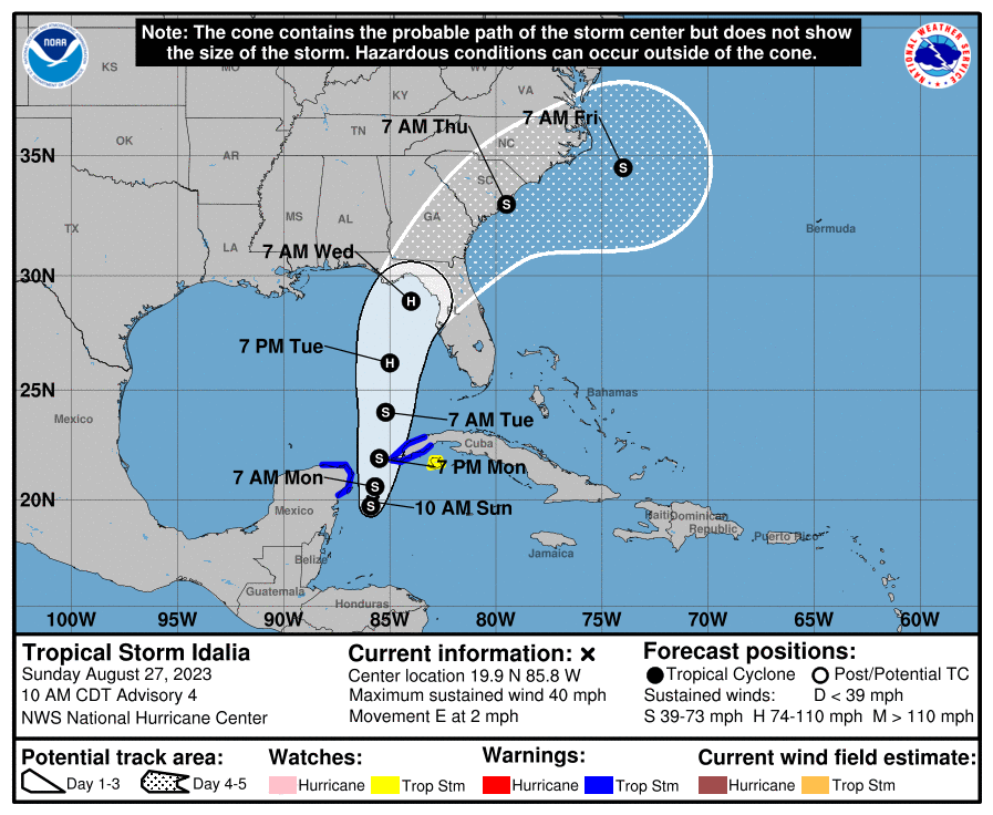
Original Post:
Current predictions from the National Hurricane Center have Tropical Storm Idalia (previously Tropical Depression 10) developing into a Cat 1 hurricane by Tuesday (the next 48 to 72 hours). It’s expected to make landfall in Florida by Wednesday. The official forecast line has it hitting somewhere between Panama City (panhandle) and Tampa Bay (peninsula). The GFS and ECMWF models are mostly predicting landfall around Apalachee bay. These predictions, both the storm track and intensity, may change as the storm develops. When the storm enters the Gulf of Mexico on early Tuesday there will be very warm waters conducive to development, but it will also be under heavy windshear.
FORECAST POSITIONS AND MAX WINDS
INIT  27/0900Z 20.1N  86.8W   30 KT  35 MPH
 12H  27/1800Z 20.1N  86.5W   40 KT  45 MPH
 24H  28/0600Z 20.6N  86.3W   45 KT  50 MPH
 36H  28/1800Z 21.7N  86.3W   50 KT  60 MPH
 48H  29/0600Z 23.3N  86.2W   60 KT  70 MPH
 60H  29/1800Z 25.7N  85.7W   75 KT  85 MPH
 72H  30/0600Z 28.5N  84.7W   80 KT  90 MPH
 96H  31/0600Z 33.0N  81.2W   45 KT  50 MPH...INLAND
120H  01/0600Z 35.0N  75.5W   35 KT  40 MPH...OVER WATER
Resources
- Tropical Storm Idalia - NHC
- CIMSS Tropical Cyclones Group
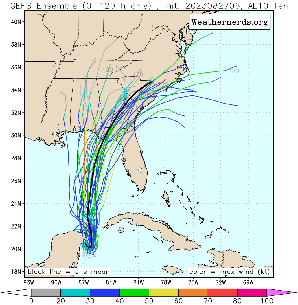
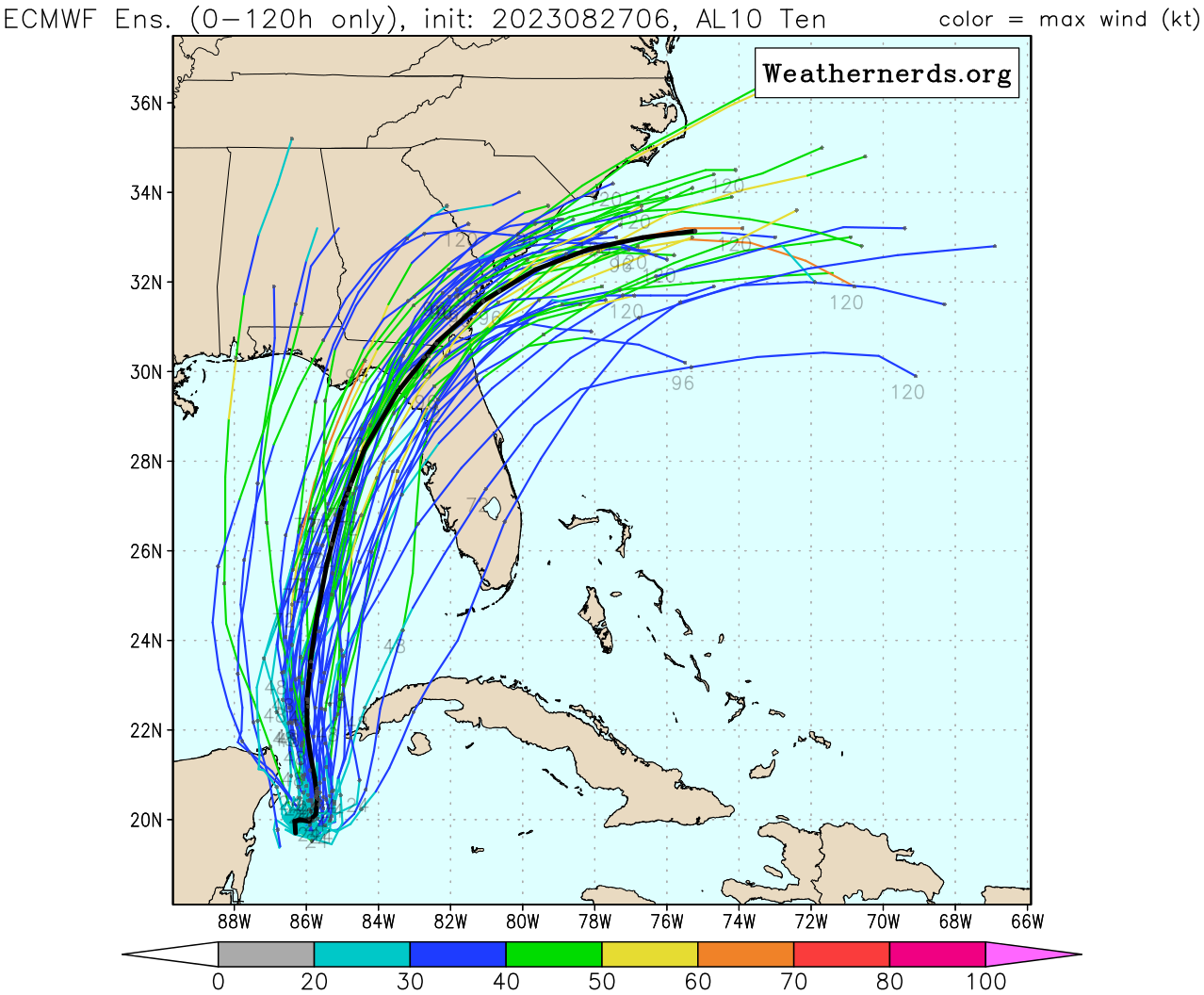
- Ensemble Forecasts for AL10 - Weather Nerds